
Miranjani track is located near Governor House Nathiagali, district Abbottabad, KPK. Among other beautiful tracks and peaks in Galiyat region, Miranjani has a significant importance being the highest peak in Galiyat.

You May Also Like:
Tilla Charouni hike || Highest point of Margalla Hills
Bari Imam hike | 11000 steps | Loh e dandi track
Meaning of Galiyat:
The word ‘Galiyat’ is derived from Urdu language meaning a street, an alley, or path between two mountains. The region hosts several alleys and paths with following names:
- Koza Gali
- Dunga Gali
- Beran Gali
- JheekaGali
- Ghora Gali
- ChanglaGali
- Khaira Gali
- Darya Gali
- Nathia Gali
Majority are in KPK while few are in Punjab namely; Darya Gali, JheekaGali and Ghora Gali.
Distance of Miranjani track from Islamabad International Airport:
Miranjani track Nathiagali is slightly above 100 km drive from Islamabad international airport via smooth Srinagar highway – Murree Expressway – GPO chowk Murree and 32 km further on a single road. As both Murree and Nathiagali are busy tourist hill station, traffic congestion is sometimes observed specially on weekend. Traffic wardens in the area are helpful and provide guidance support about the area. Tourist facilitation centers in Murree and Dunga Gali are operational to provide relevant information and guidance to tourists and visitors.
Parking at Miranjani track Nathiagali:
Parking space at the entrance of Miranjani track is open and limited with a parking fee being charged. The parking facility is also available for bikes, cars, hiace and coasters from main Nathiagali bazaar till the starting point of Miranjani track. There are different hotels and cottages owned by private entity in the area offering parking space in nominal charges.

Wildlife at Miranjani:
Nathiagali is home to various species of birds, insects, butterflies, and some wild animals. Rhesus monkeys, wild boars, peregrine falcon and common hill leopard ‘tendwa’ sighting being reported in the area. Wildlife department managing Lalazar zoo in Nathiagali are taking care for the growth and preserving the natural habitat for extinct breed of snow leopard ‘tendwa’. The area being far away from road access and urban city environment, is the best place for breeding and preservation zone for hill leopard.
Peregrine falcon in Galiyat region is another attraction for tourists and hikers. Having a top speed of 320 km / hour is the fastest animal on Earth. The bird has a sharp vision with mind boggling accuracy to dive from soaring heights to attack and catch its prey. Rhesus monkeys can be seen along the roadside. They usually do not attack and are looking for some eatables from tourists hanging around the valley.

Flora and Fauna at Miranjani track Nathiagali:
Miranjani track Nathiagali is home to various species of plants, herbs and trees. Most common trees present in the area:
- Cedar
- Oak
- Walnut
- Pine
- Maple

The area receives plenty of rain every year. The lush green valley and eco-friendly environment provides a unique hiking experience for nature lovers. During summer the flora and fauna of Miranjani is at its peak. The fresh aroma from the jungle is soothing and calming for your senses. Sighting of rare butterflies, bees and insects (snails) can be observed during hiking experience on Miranjani track. The hiss sound from the jungle during summer season (June – August) is so prevalent and loud in Nathiagali.
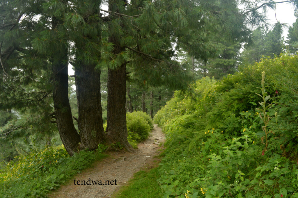
Width of Miranjani track Nathiagali
The width of Miranjani track is mostly narrow path with few patches of wide space. Track width is feasible enough for two hikers to hike parallel. At few points the width of the track gets narrower, touching becomes unavoidable for two hikers going side by side.
Is it safe to hike solo on Miranjani track Nathiagali?
The major concern of Miranjani track; having “No markings” on entire track. Marking and signboard for directions make the track easy and safe to traverse. Despite its few shortcomings, Miranjani track is one of the main attractions in Nathiagali. Hundred of tourists and hikers visit the area on a daily basis, on weekends the track is quite a happening place. Going solo on weekends during summer is a safe option to consider.
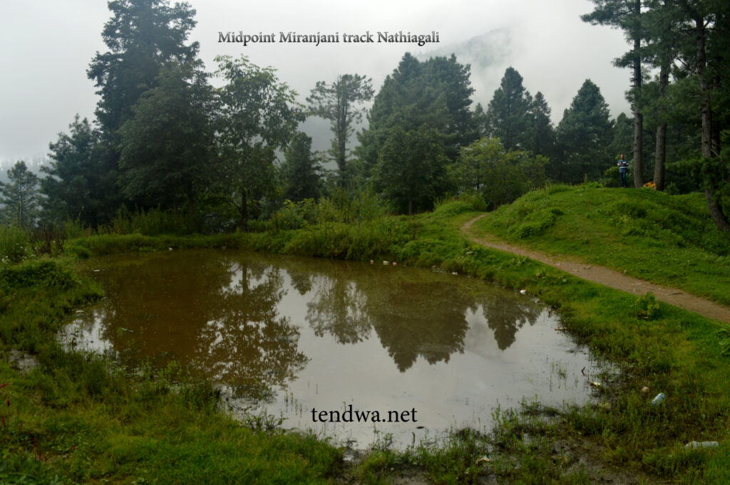
Midpoint of Miranjani track Nathiagali:
After 60 minutes of moderate to intense hike, one reaches the rainwater collection point. This area is the midpoint of the track. Hikers usually take a break at this point to regain their lost energy. The rainwater collection point serves the need of animals in the area usually cows, donkeys, horses and mules. These animals are used by locals for transportation and moving goods.
Climate of Miranjani track Nathiagali:
The weather remains cool and pleasant throughout summer (June – August). During Monsoon (15th July – 15th September) rain is expected almost every day. The weather starts to chill in autumn, with strong chilly winds dropping the temperature significantly at evening time. Winters (November – February) are very cold and chilly in Nathiagali. The area receives heavy snowfall in December and January. Miranjani track is suitable for snow hike in winters. Enthusiast hikers and nature lovers visit every year to celebrate blooming winters in snow covered area.

Miranjani top at 2992 meters:
The telecom tower at the top is the summit point standing at 2992 meters. It takes around 120 -180 minutes to reach the Miranjani top. Total distance of Miranjani track from parking till the tower is almost 4.7 km. It is safe to say a complete Miranjani hike would be somewhere around 10 km.

On a bright sunny day Nanga Parbat can be seen from this point. The views from Miranjani top are scenic. Low flight of clouds surrounding the valley is altogether a new and mesmerizing experience.
Local tea stall at Miranjani track:
After a rigorous hike, a cup of tea with freshly cooked pakora (potato chips with a coating of chickpea flour) is available to enjoy. Water bottles and soft drink juices also available and can be purchased at a nominal price.

Conclusion:
Whether you are a local tourist / hiker or an international nature enthusiast, Miranjani track is a good choice being closer to federal capital Islamabad. The area being cantonment since British rule is now looked upon by Pak Army and PAF having good security. Be mindful of the fact that Miranjani hike is a full day activity. Carry atleast 1.5 liter of water during summer along with dry fruits and nuts to gain energy. As a responsible citizen it is our duty to protect nature and wildlife so that future generations can thrive on this only livable planet.